Reading the ocean from orbit
Monitoring El Niño once meant waiting for networks of ocean buoys and coastal weather stations to piece together a picture of what was happening across millions of square kilometers of open Pacific. That process took time — often too much of it. Today, satellites have fundamentally changed the speed and clarity with which scientists can track one of the planet's most consequential climate cycles.
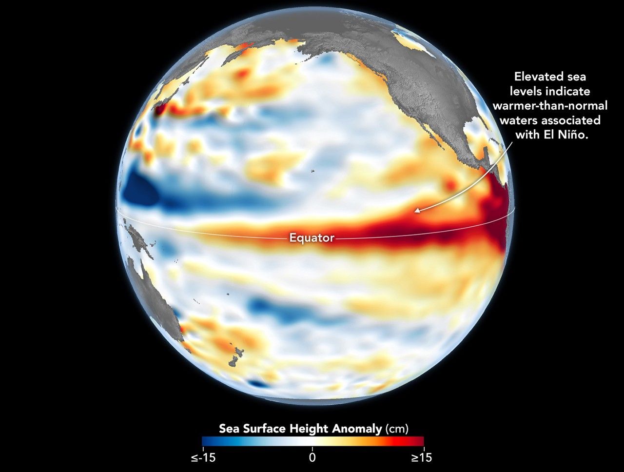
In mid-June 2026, NASA confirmed that the ongoing El Niño event had continued to intensify, based on sea surface height measurements collected by its satellite altimetry instruments. These readings reflect a well-understood physical process: as ocean water warms, it expands slightly, raising the local surface level by a few centimeters. That small but measurable change carries a significant amount of information about the heat content stored beneath the surface, particularly across the central and eastern tropical Pacific.
The tools making this possible
NASA's ability to track these anomalies relies on a lineage of precision altimetry missions stretching back to TOPEX/Poseidon in the early 1990s. Today, the Sentinel-6 Michael Freilich satellite — a joint mission with the European Copernicus program — provides continuous, high-resolution measurements of sea surface topography. By comparing current readings against established baselines, scientists can map the distribution of warm water across the equatorial Pacific almost in real time.
The data consistently shows that during active El Niño conditions, a broad pool of anomalously warm water builds across the central and eastern Pacific, suppressing the usual east-to-west trade winds and setting off a chain of atmospheric responses that reaches far beyond the tropics. Shifts in precipitation patterns, drought risk in Australia and parts of Southeast Asia, heavier rainfall along the western coast of South America, and changes in Atlantic and Pacific hurricane activity are among the known downstream effects.
What comes next remains uncertain
The continued strengthening detected in early June places the 2026 event on a trajectory that climate scientists are watching closely. Should this intensification persist through the Northern Hemisphere summer, the most pronounced impacts on weather patterns in affected regions — including East Africa, Central America, and parts of the Pacific basin — could begin to materialize by autumn.
NOAA, NASA's longstanding partner on climate monitoring, along with the European Centre for Medium-Range Weather Forecasts, regularly update their outlooks as new satellite and in-situ data come in. At this stage, pinning down the ultimate intensity of the 2026 event with confidence remains difficult. Climate models still show considerable spread in their projections for the second half of the year.
What is not in doubt is the value of the orbital vantage point. Long before El Niño's effects show up in crop failures, flooding reports, or drought declarations, the signal is already visible from space — a few centimeters of elevated ocean surface that tell a much larger story about what the atmosphere is about to do.